Cadillac Ranch is a conceptual art installation of ten ancient Cadillac automobiles (model years ranging from 1949 to 1963) planted nose-first in a field just west of the Amarillo city limit. It was created in 1974. If you'd like to learn more about Cadillac Ranch, you can read an earlier blog post about it by clicking here.
A BRIEF DIGRESSION:
On this trip to the Panhandle, I also discovered Cadillac Ranch's antipode: the VW Slug Bug Ranch near Conway, TX, about 20 miles east of Amarillo: five VW bugs (not ten Cadillacs), planted side by side (rather than nose to tail).
RETURN TO OUR REGULARLY SCHEDULED BLOG POST:
I have visited Cadillac Ranch many times over the past three years; in all my visits, however, I had only made brief stops in the middle of the day while on my way to or from Oklahoma . . . until this trip, when I was able to visit the site twice at sunset.
On both evenings people with cans of spray paint were tagging the cars with graffiti, as has become the tradition. Others were taking pictures of friends, family, themselves, or the cars:
Eventually, people drifted back to their (own driveable) cars, leaving the place relatively empty:
and, on one evening, a solitary figure contemplating the eternal beauty of nature:
If you would like to see these images in a larger format, visit my photography website, Todos Juntos Photography, by clicking here.
Thanks for coming along on this trip! Hope you enjoyed it as much as I did.
Across the Texas Panhandle I-40 traces the same route as old U.S. Route 66 . . . the "Mother Road" that millions of Americans drove between Chicago and California from 1926 until 1985. In some areas, the old road parallels the new (as above), usually as a sort of frontage road; in other places the old road has disappeared completely.
As you drive into Texas from New Mexico on
I-40, the first thing you see off in
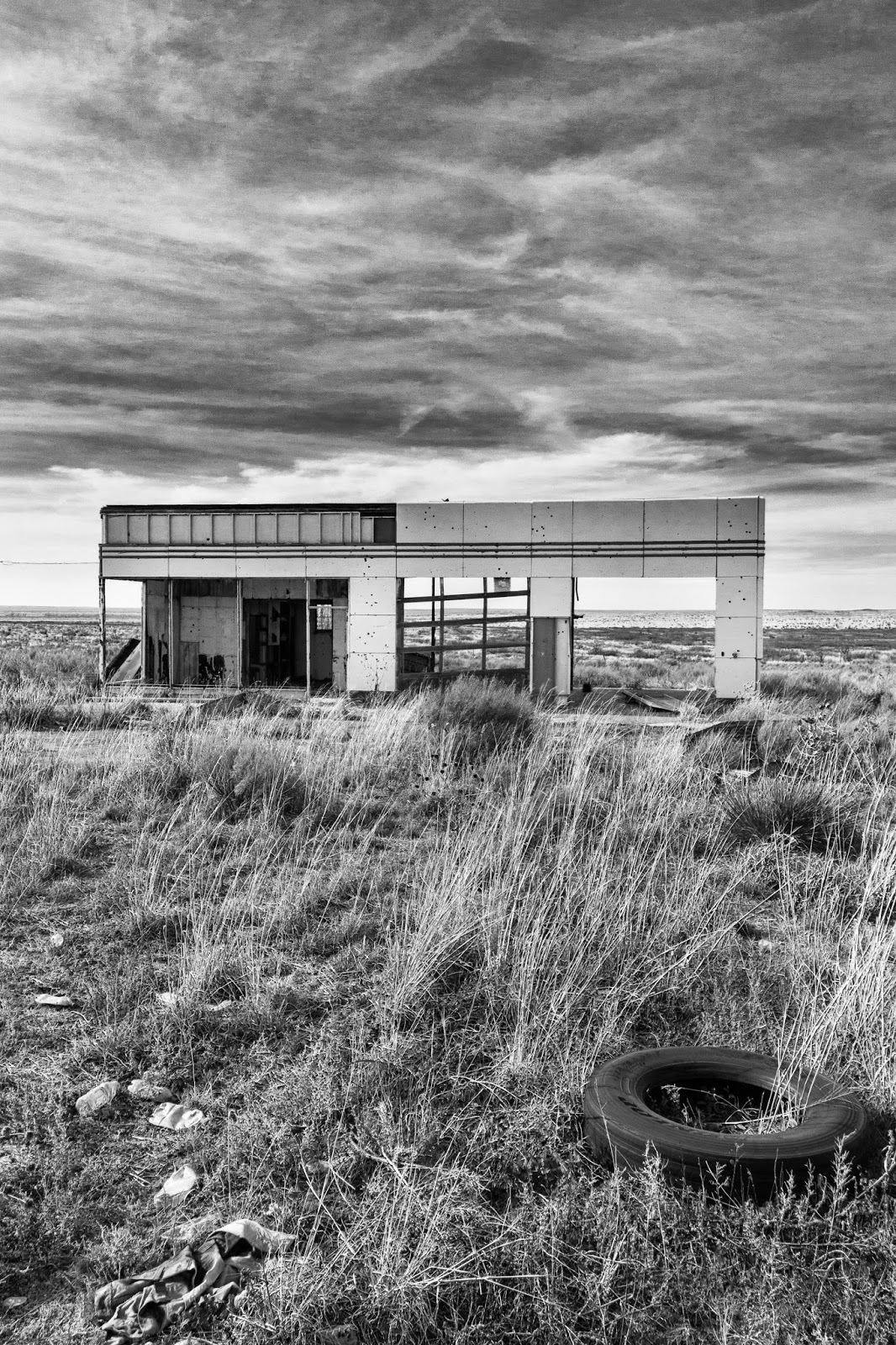
the distance is an abandoned gas station, the first sign of old Route 66 . . .
In fact, there are two abandoned gas stations right near each other, along with a lot of highway detritus . . .
. . . but to my eye the smaller one (on the left) was the more interesting photographically, both from the exterior . . .
. . . as well as through the interior . . .
Further toward Amarillo were a couple of other Route 66 reminders . . .
including that abandoned grain elevator you saw in an earlier post:
If you would like to see these images in a larger format -- as well as the color versions of them -- visit my photography website, Todos Juntos Photography, by clicking here.
I have also photographed Route 66 relics in New Mexico. You can see and read about them in a previous post on this site by clicking here.
The next, and final, post in this series will be about Cadillac Ranch, an art installation just west of Amarillo.
As with any other territory, the Texas Panhandle has its share of old and abandoned houses, buildings, and equipment. On the plains, however, they seem lonelier than in the city.
And here's a sneak preview of what you'll see in the next post about old U.S. Route 66:
If you would like to see these images in a larger format, visit my photography website, Todos Juntos Photography, by clicking here.
Christians in the Texas Panhandle are not shy about expressing their beliefs, either in words or symbols. Two examples: the towns of Clarendon and Groom, TX.
Clarendon is a small town (population about 1,900) 60 miles southeast of Amarillo on US Highway 287, the main route from Amarillo to Ft. Worth. The welcome sign at the city limit is a windmill -- one of the familiar Panhandle icons:
But look closely right below the Chamber of Commerce sign:
The signs continue all the way through town:
Up the road a bit, and 40 miles east of Amarillo is Groom, population about 550.
Here the Blessed Mary restaurant bears witness:
But even more striking is the famous Groom Cross at a church just off I-40 less than a mile from town:
The free-standing cross is 190 feet tall and weighs 1,250 tons. It was erected in 1995 and is visible for miles (right up there with the wind turbines):
Here are two articles with different perspectives on the cross: reverent and irreverent . . . take your pick.
If you'd like to see these images in a larger format, visit my photography website, Todos Juntos Photography, by clicking here.
Next: old buildings.
Until the giant wind turbines came along, the tallest structures on the Texas Panhandle landscape were grain elevators, affectionately known as "Prairie Skyscrapers."
Essentially a series of interconnected silos, these massive structures were placed every few miles along highways . . .
or beside railroad tracks . . .
to facilitate the storage and distribution of harvested grains such as wheat, oats, corn, barley, etc.
On the level land of the Texas Panhandle, the elevators can be seen for miles:
Grain elevators were invented in 1842 by Joseph Dart and Robert Dunbar in Buffalo, NY, to address the need to load and unload massive amounts of grain being shipped via the Erie Canal. As settlers moved westward and the Great Plains of the central U.S. were used for agriculture, grain elevators followed the growth of the railroads and the advent of the mechanical harvesting equipment. If you are interested in knowing more about how a grain elevator operates, there's a simple article and diagram here.
The reinforced concrete silo construction that most of us associate with grain elevators came into use in the early 20th century. But it was preceded by the wood-cribbed elevator structures that continued to be built well into the 1930s. Here are a couple of abandoned wood-cribbed elevators:
More recently, steel bins have come into use, either as primary storage or as additional "annex" storage adjacent to the larger silo structures:
. . . all connected by an elaborate system of conveyor belts and spouts to create mixtures or blends of grains drawn from the different interconnected silos:
But the structure that caught my eye was a two-silo concrete elevator and its associated workhouse (office) about 30 miles west of Amarillo that was apparently abandoned in 1990:
The windows are broken . . .
the inspection and weight certificates left behind in a drawer are spattered with bird droppings, as are the scales:
But from a distance, in the pre-dawn and early morning light, it photographs well:
To see these images in a larger format, visit my photography website, Todos Juntos Photography, by clicking here.
Next: religious iconography.