Friday, June 29, 2018

Utah Photo Expedition - Day 4


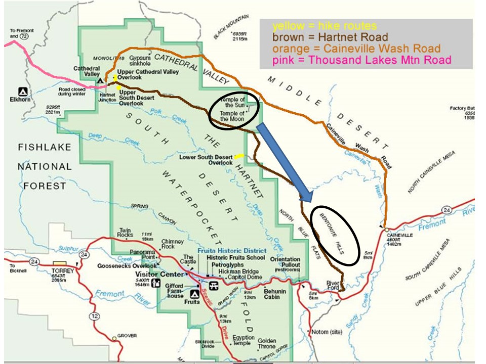
After exploring Cathedral Valley loop on Day 3 in the northern section of Capitol Reef, we went south on Day 4 to explore parts of the nearly 100-mile-long Waterpocket Fold.


The Fold is a monocline, where the crust of the earth has been uplifted, revealing many different layers of sedimentary rock laid down over a period of 200 million years.  If you would like to read more about this geology, click here.

Bruce and I were interested in whatever photographic opportunities the geology provided.  So once again we headed out early to catch the dawn light on the east slopes of the Fold.  


As on Day 3, the moon was setting in the west, so we included it as long as we could:


Then we turned to the shapes, textures, and colors of the rock formations:


But the most interesting part of the day was a hike into the Fold itself:


Spaces between sections of the Fold form canyons with multi-layered (and multi-colored) walls 200-300 feet high, made of sediments laid down millions of years ago:


Not far from the mouth of the canyon, the walls get closer together to form a very dark and narrow slot canyon:


(Feeling claustrophobic yet?)


The slot canyon runs for about 75 yards, then opens up into another huge area:


This section of the canyon is filled with beautiful desert textures and colors in rocks and plants:


Eventually, however, we reached the end of the canyon . . .


. . . so we retraced our steps back to the car, 


then returned to Torrey for one more night.

If you would like to see these images in a larger format, please visit my photography website, Todos Juntos Photography, by clicking here.


Enjoy!


Tuesday, June 26, 2018

Utah Photo Expedition - Day 3


Capitol Reef National Park, in south central Utah, is 378 square miles of amazing geological formations.  But most people only see what's visible along the 12-mile-long section of Utah highway 24 that cuts through the Waterpocket Fold along the Fremont River.

Certainly the area along Route 24 is majestic, with 500- to 600-foot cliffs . . .


overlooking a peaceful river valley complete with orchards and livestock:


But there are vast, less easily accessible, areas of Capitol Reef that few people see, and Bruce and I came to explore them.

The most attractive area to us was Cathedral Valley, accessible via a 57-mile loop of unpaved -- and in some stretches very rough -- road.  And depending on whether you drive the loop clockwise or counterclockwise, you have to begin or end your trip by driving across the Fremont River!  (Fortunately, most days it's not too deep.)

So we left our motel in Torrey, UT (on the west side of Capitol Reef) long before dawn so that we could start at the far end of the loop near Caineville, saving the river crossing for last.  Our goal was to get to the most dramatic formations in Cathedral Valley at sunrise:  two giant sandstone monoliths dubbed the Temple of the Sun and Temple of the Moon.


The sky was full of clouds, and we had no idea whether they would break enough to illuminate the Temples, but they made for a beautiful sunrise:


In a race with the sunrise, we made it to the area where the Temple of the Sun and Temple of the Moon stood.  The sun was mostly obscured by the clouds, but the moon setting in the west was visible.


This is the Temple of the Sun (without direct sunlight):


Fortunately the sun would intermittently shine through small breaks in the clouds and briefly illuminate the 400-foot high monolith:


Nearby was the Temple of the Moon, a little shorter than the Temple of the Sun, but imposing nonetheless -- seen here with the Temple of the Sun in the background.


And again the sun emerged through breaks in the cloud layer to give us a dramatic view of the Temple of the Moon:


When the clouds took away the sun for a while, we continued west on Caineville Wash Road through Cathedral Valley, with tall sandstone cliffs along either side:


At one point we found the remnants of a volcanic dike wall similar to the ones around Shiprock:


We turned north off of Caineville Wash Road to check out a feature outside the national park called Solomon's Temple (in the distance in the photo below):


On our return to the Cathedral Valley loop, the pesky cloudy sky had some drama, including a lenticular formation that looked like a giant flying saucer:


At the westernmost point of the loop drive we found more sandstone monoliths.


As we made our way back toward the other end of the loop (and the river crossing) the road took us up about 1,000 feet in elevation above the valley.  


At one point, we hiked a mile off the road to get a view of the Temples of the Sun and Moon from an overlook strewn with giant rocks.


The view was magnificent, even though we were still battling the clouds for sunlight:


Temple of the Sun (left); Temple of the Moon (right)


Temple of the Sun


With the sky almost completely overcast, we drove down through hills of Bentonite, a kind of clay made of weathered volcanic ash.


                                   (Notice the tracks of off-road vehicles on this fragile hill above.)


Finally, it was time for our last challenge:  fording the Fremont River.


We had visited the ford the day before, and had tested the depth with sticks to assure ourselves it wasn't too deep for the car.  Still, when you're about to drive your car (or in this case, Bruce's car) into a river, you take a deep breath.


The entrance and exit points for the ford are not opposite each other -- they are offset by about 50 yards.  From the side we were entering, you have to drive all the way across, then turn right (upstream) along the far bank and drive along the bank to the exit.  You can see the exit road in the distance in the photo below.


So here we go . . .


Almost there . . .


Made it!  Whew!


If you would like to see these images in a larger format, please visit my photography website, Todos Juntos Photography, by clicking here.

Enjoy!