Besides being near the Great Sand Dunes National Monument, Alamosa, Colorado, hosts something of a railcar graveyard -- dozens of retired railroad cars and engines from all over the country.
After catching the early light at the dunes, my photo buddies (Barry and Alan) and I spent a morning last August exploring and photographing these rusting relics.
The paint is peeling . . .
And the windows are cracked and broken . . .
But these cars and engines still retain some of their romance and grandeur . . .
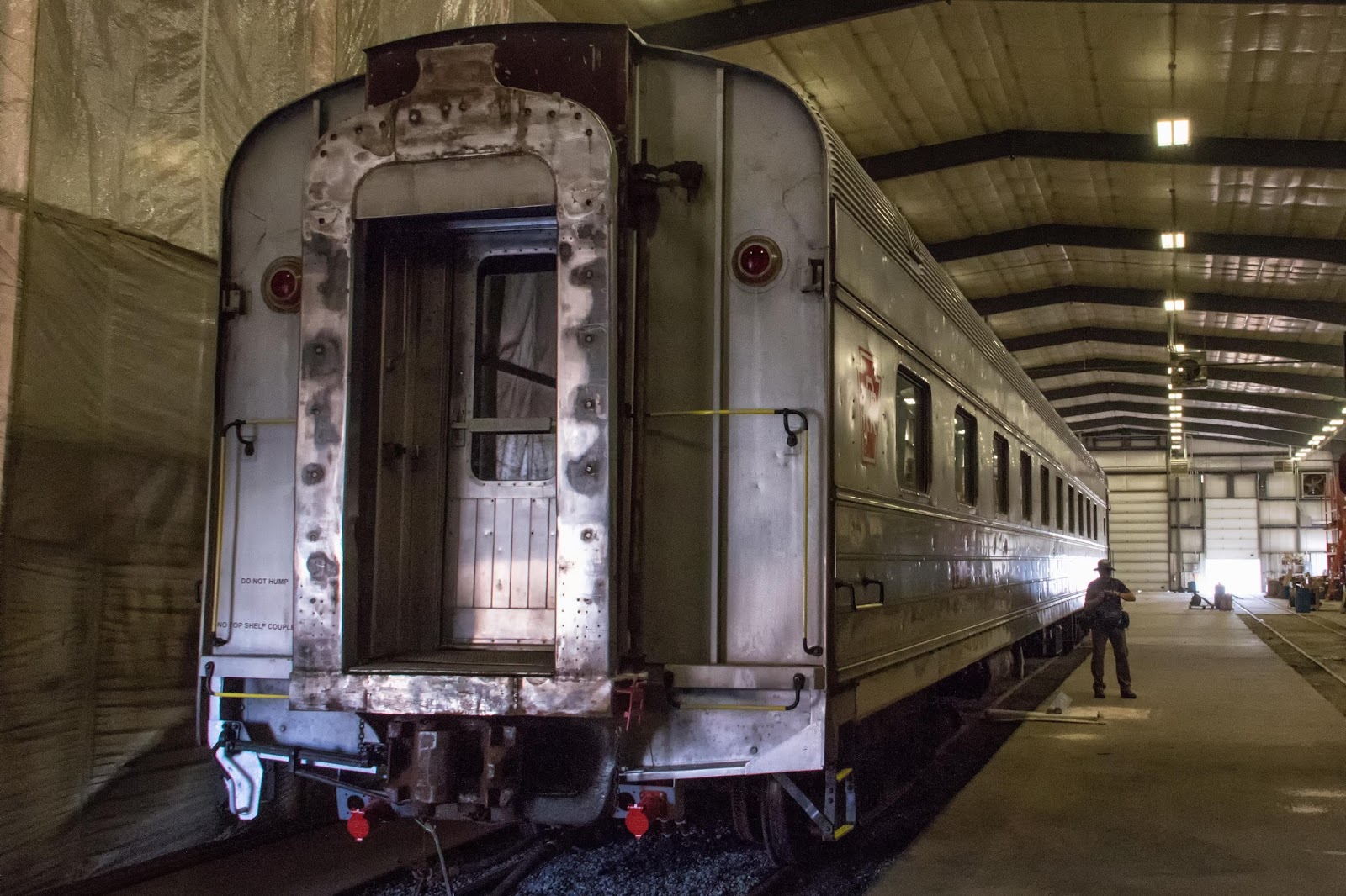
We were also able to poke around in a repair barn, where some of the cars and engines are being refurbished and maintained for the Rio Grande Scenic Railroad which operates from Alamosa (about which find more by clicking here or here).
And I couldn't resist photographing this notice painted on one of the passenger cars:
For those of you who don't know railroading, you can learn what it means by clicking here. (Tsk, tsk. You and your dirty mind.)
One last image . . .
If you would like to see these images (and more) in a larger format, please visit my photography website, Todos Juntos Photography, by clicking here.
Enjoy!
About 25 miles northeast of Alamosa, nestled up against a southern branch of the Rocky Mountains in south-central Colorado, is the Great Sand Dunes National Park and Preserve.
 The park was designated as a national monument by Herbert Hoover in 1932, and was made a national park by Congress in 2004. It contains the tallest sand dunes in North America (over 750 feet high), and encompasses over 85,000 acres of park and protected areas.
In August, 2016, I traveled with my photo buddies Barry and Alan to photograph the park.
We arrived at the park in late afternoon, right after a light rainstorm, and the dunes looked like a small mountain range in front of the larger (real) mountains beyond.
The park was designated as a national monument by Herbert Hoover in 1932, and was made a national park by Congress in 2004. It contains the tallest sand dunes in North America (over 750 feet high), and encompasses over 85,000 acres of park and protected areas.
In August, 2016, I traveled with my photo buddies Barry and Alan to photograph the park.
We arrived at the park in late afternoon, right after a light rainstorm, and the dunes looked like a small mountain range in front of the larger (real) mountains beyond.
Compared to the 12,000-ft. high mountains in the background, the dunes may not seem so high. But for comparison, here's an image with a section of Boston's Back Bay skyline superimposed for scale at roughly the same distance:
Thanks to the rain, the shallow creek that flows out of the mountains and bounds the eastern and southern side of the dunes had a bit of water in it.
We crossed the creek and headed across the flats to the dunes. Now you can really begin to see the relative size more clearly. Those two tiny dots in the distance on the far right of the image are people.
Because of the rain, footprints in the sand made very distinct trails. Those dots in the center and upper right of the image are people.
Then it was time to climb.
The dunes are a lot steeper up close than they looked from far away:
Even with slightly wet sand the dunes are steep enough for kids to zoom down in their saucers.
Wheeee!
As we climbed, we could see other visitors on different dunes:
A family from somewhere in Europe, apparently quite accustomed to hiking, charged up the dune . . .
. . . and father and son had a great time:
The woman and man in this image were not related (I learned later), but I thought it made a great picture:
The sun set, and we got a little color out of the overcast day as we made our way back to the car.
The next morning we returned to catch some early light and different shadows on the dunes. The previous afternoon's rain had freshened the vegetation in the foothills surrounding the park:
In the morning light we found some dramatic scenes as we approached . . .
With the direct sunlight, some of the dunes took on an abstract look:
. . . or like the surface of Mars:
Barry and Alan at work . . .
and kids at play in the creek:
One last look before we headed back to Alamosa:
NEXT POST: Alamosa Railcar Graveyard
If you would like to see these images in a larger format, please visit my photography website, Todos Juntos Photography, by clicking here.
Enjoy!
On a cloudy day last August, I set out on a photo expedition with my photo buddies Barry and Alan up through northern New Mexico to Alamosa, Colorado, about 200 miles north of Corrales. Our primary goal was to photograph the Great Sand Dunes National Park, which is northeast of Alamosa. I'll provide images from the park in my next post.
Being photographers, however, we enjoy the journey as much as the destination because we will stop and shoot whenever anyone sees something they want to capture.
Our first stop was Ojo Caliente, a tiny village about halfway to Alamosa. Its claim to fame is a first-class hot springs spa, which Linda and I visited in early 2016; you can read about it by clicking here.
But on this trip the attraction was the village cemetery. Cemeteries in rural New Mexico are typically scrubby and stark -- not like the well-groomed cemeteries in more lush environments. But they are always filled with beautiful grave decorations, showing that, as in other locales, they are active, living memorials to those laid to rest there.
Sometimes the decorations are simple . . .
 . . . and sometimes they are elaborate.
After leaving Ojo Calilente, we drove north through the Carson National Forest on US 285 and emerged onto the Taos Plateau, a vast plain of basalt and alluvium between US 285 and NM 522 on the map below.
. . . and sometimes they are elaborate.
After leaving Ojo Calilente, we drove north through the Carson National Forest on US 285 and emerged onto the Taos Plateau, a vast plain of basalt and alluvium between US 285 and NM 522 on the map below.
On the map and at ground level it looks like a whole lot of nothing, but from a
geologic perspective it is one of the most dynamic and interesting areas
on Earth. You can read more about the geology by clicking here.
This is a view of the Taos Plateau from US 285 looking southeast. Needless to say, we had some good summer storm cloud action going . . .
. . . and I happened to push the button at just the right moment to catch a bolt of lightning.
We stopped for a couple more roadside attractions. An abandoned grocery store . . .
and a family shrine of some sort just south of Antonito, CO.
As we were photographing the shrine, we heard a train whistle and realized that we were only half a mile away from the eastern terminus of the Cumbres and Toltec Scenic Railroad which runs between Antonito, CO, and Chama, NM. (If you'd like to know more about the C&T, click here).
The train was just pulling into the station, so we dashed over and grabbed some dramatic images of the magnificent Baldwin K-36 2-8-2 steam locomotive #484, built in 1925. Right place at the right time!
After photographing the train, we continued to Alamosa and on to the Great Sand Dunes National Park. As we approached, it was raining over toward the park, creating a beautiful cloud formation, but that didn't deter us.
NEXT POST: Great Sand Dunes National Park and Preserve
If you would like to see these images in a larger format, please visit my photography website, Todos Juntos Photography, by clicking here.
Enjoy!