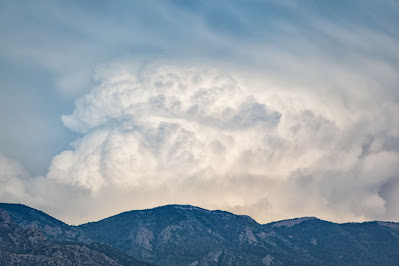
This is the first in a series of three posts, all depicting monsoon cloud action visible from my neighborhood in Corrales, New Mexico, over a three-day period June 10-12, 2025. The images in this post are from June 10; images from June 11 and 12 will appear in separate forthcoming posts.
△ ▽ △ ▽ △ ▽ △ ▽
Out here in the Southwest, we're now in "monsoon season," the three months from mid-June to mid-September when we get half our annual rainfall (which means we get about 4-5" -- woo hoo!). As the weather systems crank up, we are treated to some magnificent displays of clouds . . . with little if any actual rain.
A few weeks ago, just ahead of the season, we had three days in a row of great cloud shapes and colors that I'd like to share with you here. We begin with June 10.
On this evening there were four distinct cloud formations in separate areas of the sky. Each formation evolved/moved over time, and in one case began to merge into each other. There were also a couple of random, isolated formations unrelated to the primary ones. I'll show you examples of each area/category.
ISOLATED CLOUD FORMATIONS
CLOUD TSUNAMI WAVE - Looking Southeast
Rising above the Sandia Mountains was an immense cloud formation that looked like a giant ocean wave. Over the space of about 30 minutes it morphed into the shape of a giant fish head:
CLOUD WITH VIRGA - Looking South
Virga is falling rain that doesn't reach the ground, like the dark streaks coming out of the underside of this formation:
Just to the right (west) of the virga cloud was another formation. You can see both of them in this image:
Here's the southwestern cell by itself . . .
. . . and the sky above it:
NORTHWESTERN CLOUD SHELF
Most dramatic was the shelf of clouds moving toward and above me coming from the northwest:
As the leading edge passed overhead (moving left to right in the image below), the trailing edge left openings for the setting sun to shine through:
The leading edge passed overhead moving south-southeast toward the Sandia Mountains and the virga formation to the south . . .


wonderful time lapse from weather dog - would make a great time lapse video? / Barry
ReplyDelete